 Back to Culture & Heritage
Kondoa Rock-Art Sites
Overview & Highlights
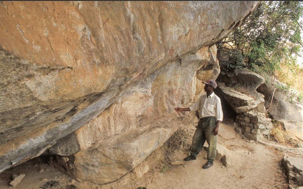
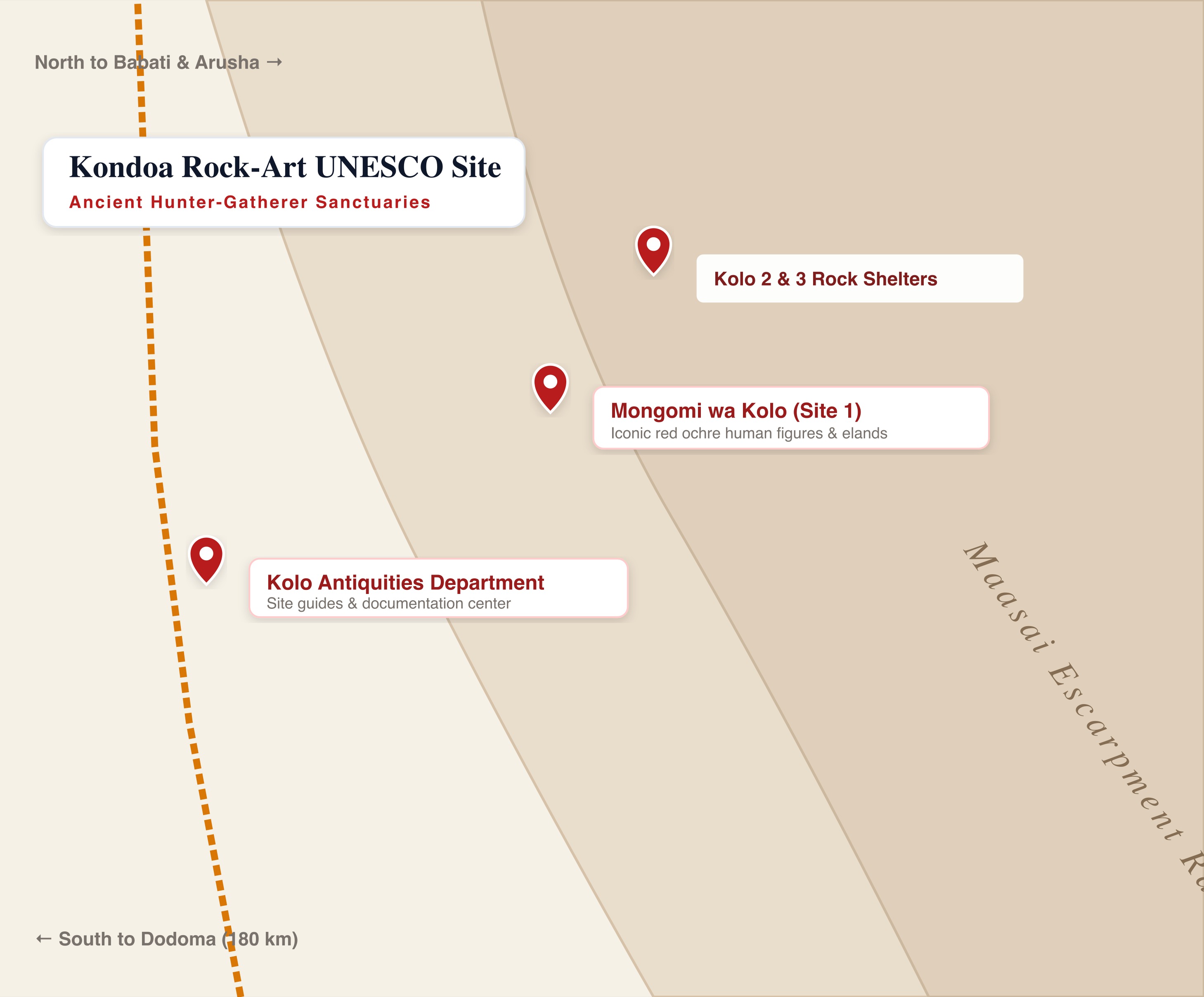
The Kondoa Rock-Art Sites form a UNESCO World Heritage cultural sanctuary set along the dramatic granitic boulder-strewn slopes of the Maasai Escarpment in central Tanzania. Across an area of over 2,300 square kilometers, archaeologists have documented between 150 and 450 natural rock shelters containing thousands of prehistoric paintings. Created over at least two millennia by ancestral hunter-gatherers and later pastoralists, the paintings depict elongated human figures, masked ritual dancers, bows and arrows, and wild animals — with particular reverence shown to the giant eland antelope. The rock art possesses deep living spiritual value: modern Warangi and Sandawe communities continue to use several shelters for traditional rainmaking, healing, and initiation ceremonies. The primary access hub is Kolo village, where antiquities guides interpret the mesmerizing panels of Mongomi wa Kolo (Kolo 1).
Highlights & Key Activities
- Mongomi wa Kolo (Kolo 1): Iconic rock shelter with exquisite red-ochre human silhouettes
- Kolo 2 & 3: Paintings of masked ritual dancers and majestic elands
- Kolo Antiquities Department documentation center and guided interpretation
- Dramatic hiking trails along the rugged granitic boulder slopes of the Maasai Escarpment
What We Love
- Extraordinary UNESCO World Heritage prehistoric rock paintings spanning over 2,000 years
- Pristine, non-commercialized wilderness setting along the scenic Maasai Escarpment
- Living spiritual significance with ongoing traditional rainmaking rituals
- Invigorating hill hikes with sweeping panoramic views across the Maasai Steppe
- Conveniently located along the paved Great North Road connecting Arusha and Dodoma
Keep in Mind
- Requires uphill walking on rugged, unpaved hillside trails
- Rustic visitor facilities at the Kolo Antiquities site office
- Shelters are dispersed across the hills; visiting multiple sites takes a full day
Best Things to Do in Kondoa Rock-Art Sites
Hike to Mongomi wa Kolo (Site 1)
Trek up the wooded escarpment to stand before the best-preserved red ochre paintings of ancient hunter-gatherers.
Explore Kolo 2 & 3 Shelters
Discover depictions of ancient animal traps, archers, and sacred elands painted by ancestors of the Sandawe.
Kolo Antiquities Museum Briefing
Meet local conservationists and learn about the pigment chemistry (red ochre, animal fat, and plant resin) used to create the paintings.
Cultural Encounter with the Warangi & Sandawe
Learn how modern local communities continue to perform traditional rainmaking and healing rituals at the painted rock shrines.
Best Time & Climate
The long dry season from June to November is the best time to explore Kondoa. Trails are dry and easily passable, and humidity is pleasantly low. The rainy months (December to April) make trails slippery.
☀️ Dry Season
June to November (Clear skies, dry rocky trails, excellent visibility)
🌧️ Wet Season
December to April (Vegetation is lush, but trails can be muddy and slippery)
Monthly Visitor Guide
Sub-humid tropical highland climate. Pleasant warm days with crisp, cool evenings along the escarpment.
Climate Chart (Temperature & Rainfall)
Getting There
Kondoa is situated halfway between Arusha and the national capital of Dodoma along the Great North Road (T1), making it an easy scenic road journey.
Driving Routes Matrix
| Route From | Distance (km) | Est. Time | Road Condition |
|---|---|---|---|
| Arusha | 240 km | 3 hrs 30 mins | Smooth paved tarmac highway via Babati |
| Dodoma | 180 km | 2 hrs 30 mins | Smooth paved tarmac highway |
| Tarangire National Park | 160 km | 2 hrs 30 mins | Paved tarmac |
✈️ Air Travel & Local Airstrips
Visitors can fly into Dodoma Airport (DOD) or Arusha Airport (ARK) and arrange private vehicle transfers.
Safety, Malaria & Guidelines
Operational Advisory
Always obey local safety parameters, environmental codes of conduct, and instructions from park rangers or guides.
Kondoa is a quiet rural region with welcoming local communities. All visits to rock art shelters require an official Department of Antiquities guide from the Kolo Information Centre. Visiting the shelters requires moderate uphill hiking along rocky, uneven hillside trails; wear sturdy hiking boots or shoes with good grip and carry sufficient drinking water. Avoid touching the rock faces or splashing water on paintings, as moisture damages ancient mineral pigments.
🦟 Malaria & Health Advisory
Malaria is present in most wildlife reserves in Tanzania. It is strongly recommended to consult a travel clinic for antimalarial prescription. Use mosquito repellent containing DEET and wear light-colored, long-sleeved clothes in the evening.
Recommended Safari Tours Visiting Kondoa Rock-Art Sites
 4 Days • luxuryFrom $2,660/pp
4-Day Safari - High-End
If you only have 4 days but still want to visit the most famous parks of Tanzania (Serengeti, Ngorongoro, and Manyara or Tarangire), this is the perfe...
6 Days • luxuryFrom $2,870/pp6-Day Mid-Luxury Private Wildlife Safari & Walking Tour
On this 6-day safari, you will experience the best that Tanzania has to offer, including 2 nights in the Serengeti, home to over 3 million animals. Yo...
5 Days • luxuryFrom $2,562/pp5-Day Luxury Splendor of Tanzania's Grand Wild Safari
Embark on a 5-day journey through Tanzania's untamed beauty. Experience the epitome of luxury in the renowned Serena Hotels across Serengeti, Ngorongo...
5 Days • luxuryFrom $3,330/pp5-Day Living Among Lions - Luxury (with Four Seasons)
This is one of our most popular tours as it allows you to spend a very reasonable amount of time in the Serengeti (2 nights). You'll still have the ch...
TripAdvisor Traveler Reviews
Traveler feedback:
1. 'Standing in front of the Mongomi wa Kolo paintings was mesmerizing. The red ochre figures look as vibrant as if they were painted yesterday. A profound window into ancient Africa.' (Rating: 5/5, Date: May 2026)
2. 'Off the beaten tourist trail between Dodoma and Arusha. The hike up the escarpment through wild baobab trees is gorgeous. Our guide was exceptional.' (Rating: 5/5, Date: April 2026)
3. 'A must-visit for archaeology and anthropology enthusiasts. Peaceful, unhurried, and authentic.' (Rating: 5/5, Date: February 2026).
Configure Adventure
Add this attraction to your trip dashboard. Once added, you can customize your overall budget.
Find Stays Near Attraction
Get real-time availability and discount rates for lodges near Kolo via the LiteAPI hotels engine.